

 TARRANT COUNTY, TX

 Tarrant County Archives
Maps and Plans
Maps and Plans
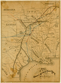
Tarrant County Archives has an extensive collection of local and regional maps, plats and architectural plans. We are working on a database covering the entire collection. Below is a list of examples which will grow in the future. Some are copies and not originals. If you are seeking a particular map covering Tarrant County, the Archives will be happy to help
The map database will provide you an inventory of our collection of maps:
The Transportation Map Index represents the most recent inventory of the maps housed with Tarrant County Transportation Services. Please contact the Archives for assistance.
Additional historic Tarrant County maps may be found in the Transportation Department Collection.
Examples:
- Tarrant County Plat Maps
- Mansfield Plat Maps
- Wedgwood Addition Plat Maps
- Mistletoe Heights and Dedication
- General Land Office 1885
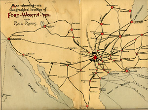
- Sam Street's 1895 Map of Tarrant County
- Fort Worth, 1925
The following indexes are available in PDF format. Once the PDF is open, either browse by date or right click anywhere on the document and select "Find" from the drop-down box to enter a search term. The index to the holdings of the Tarrant County Archives will be posted in sections as they are ready for publication. The Archives thanks volunteers Caroline Craig and Gregory C. Schadt for their work on completing Section 1.
Tarrant County Sanborn Fire Insurance Maps available through the University of Texas at Austin:
- Arlington - 1900, 1905, 1911, 1917
- Fort Worth - 1885, 1889, 1893, 1898, 1910, 1911, 1923, 1926
- Grapevine - 1921, 1935
- Mansfield - 1921
The following map shows locations of cemeteries within Tarrant County as of February 2011. Sources: Texas Historical Commission, TxDOT Public Comments, Cemetery Websites, and Tarrant County Historical Commission.